Posts

Chesapeake Bay Bridge-Tunnel

Image
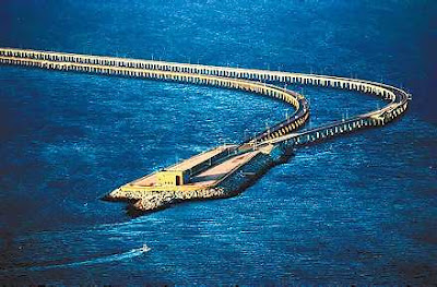
Chesapeake Bay Bridge-Tunnel The  Chesapeake Bay Bridge-Tunnel ( CBBT )  is a 23 mile long bridge and tunnel system that connects southeastern Virginia with Delmarva Peninsula in the United States. The bridge connects the following independent cities Virginia Beach, and Norfolk, Virginia to Cape Charles in Northampton County along the eastern shore of Virginia. The Chesapeake Bay Bridge-Tunnel uses a combo of tunnels and bridges over two separated shipping channels using four artificial islands built in the bay as portals. The bridge-tunnel was opened on April 15th, 1964, in August 1987 it was officially named the Lucius J. Kellam Jr. Bridge-Tunnel after one of the civic leaders who worked for its development. However, it still is best known as Chesapeake Bay Bridge-Tunnel. The bridge part of the Chesapeake Bay Bridge-Tunnel as far as I can know is 15.6 Miles long which is why this bridge is placed at number at the worlds 9th longest bridge and 7th longest over water and 4th

Underground Skyscraper in Mexico City

Image
The Earthscraper, designed by  BNKR Arquitectura , is the Skyscraper’s antagonist in the historic urban landscape of Mexico City where the latter is condemned and the preservation of the built environment is the paramount ambition. It preserves the iconic presence of the city square and the existing hierarchy of the buildings that surround it. More images and architects’ description after the break. The Historic Center of Mexico City is composed of different layers of cities superimposed on top of each other. When the Aztecs first came into the Valley of Mexico they built their pyramids on the lake they found there. When a new and bigger pyramid was conceived and the Aztec Empire grew in size and power, they did not search for a new site, they just built on it and around the existing one. In this manner, the pyramids are composed of different layers of historical periods. When the Spanish arrived in America and ultimately conquered the Aztecs, they erected their Christian temple

The Magdeburg Water Bridge

Image
The Magdeburg Water Bridge  (German: Wasserstraßenkreuz) is a navigable aqueduct in Germany, opened in October 2003 . It connects the Elbe-Havel Canal to the Mittellandkanal, crossing over the Elbe River. It is notable for being the longest navigable aqueduct in the world, with a total length of  918 metres (3,012 ft). The Elbe–Havel Canal and Mittelland Canal canals had previously met near Magdeburg but on opposite sides of the Elbe, which was at a significantly lower elevation than the two canals. Ships moving between the two had to make a 12-kilometre (7.5 mi) detour, descending from the Mittelland Canal through the Rothensee boat lift into the Elbe, then sailing downstream on the river, before ascending up to the Elbe-Havel Canal through Niegripp lock. Low water levels in the Elbe often prevented fully laden canal barges from making this crossing, requiring time-consuming off-loading of cargo. History Canal engineers had first conceived of joining the two waterways as far back as 1

JNTU KAKINADA MECHANICAL 3-2 MID 1 ONLINE BITS

Download JNTU MECH 3-2 (2012) second Mid Online Bits in PDF Subscribe to feed through email,not to miss any updates. Download JNTU MECH 3-2 (2012) second Mid Online Bits subject wise 1. MSE 2. TE-II 3. CAD/CAM 4. DMM-II 5. IM * We are not responsible of any conseqences

Students in Exam Hall

Image
     FUN TIME EXAMTIME This is the following animations seance that the four active students with a teacher in the Exam Hall.

THE LIFE'S RACE

Image
   THE RACE OF LIFE               another super hilarious animation from the web :P :D

JNTU KAKINADA CSE/IT 3-2 MID 1 ONLINE BITS

Download JNTU CSE/IT 3-2 (2012) second Mid Online Bits in PDF Subscribe to feed through email,not to miss any updates. Download JNTU CSE/IT 3-2 (2012) second Mid Online Bits subject wise 1. CD 2. IS 3. CN * We are not responsible of any conseqences